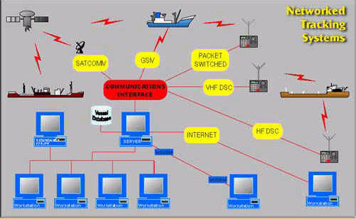
Accueil compagnie   points de vente tech support
achat contact tarif anglais downloads
 
sunseeker

plaisance


seaPro lite


seaPro standard


seaPro performance


seaPro plus


professionnel


seaPro pêche


seaPro pro


seaPro patrol


PI3000 passenger info


mises à niveau


Logiciel et matériel


cartes et données


Livecharts (vectorielles)


ARCS (raster)


S57 (ENC vectorielles)


Navionics (vectorielles)


Produits Admiralty ADP


ATT - Total Tides


  DLRS- Radio Signals  
  DLL List of Lights  
  Produits Admiralty Digital  

développement oem


kit de cartographie oem


matériel


Récepteurs AIS


Transpondeurs AIS


Convertisseurs USB/série


Récepteur Navtex 2


météo  

Worldwide Vessel/Fleet Tracking System

Fleet Tracking

By marrying sophisticated multi-vessel plotting capabilities with an internal vessel database.

The seaPro 2000 Worldwide Fleet Management system becomes an enormously powerful tool for monitoring, planning and scheduling your entire fleet– whether tugs and tenders, trawler fleets, patrol vessels or foreign-going merchantmen.


Application areas:

Port authority vessel tracking
Monitoring traffic in remote locations, where radar surveillance is not viable
Rescue co-ordination services
Race information
Passenger information systems
Vessel identification
Commercial tracking and vessel location using Inmarsat 'C'
For cruise vessels - as a sales tool to show where the vessels are to potential clients and a service to your customers friends and relatives
(Web site rendering extension required)


Scalable solutions

Built using the seaPro charting system, and working with a range of top quality raster (ARCS/Seafarer/BSB) and vector (Livechart/S57.3 derived) cartography, Euronav's tracking systems can operate in standalone or networked modes, and may be configured to work with your existing communications infrastructure.

Worldwide capability
The system supports the following high-quality electronic charts:

Livechart 'B' (vector)
S-57 ENC (vector)
ARCS (raster)
Seafarer (raster)
BSB (raster)

Together you have access to charts covering just about any where in the world

The system can also be combined with other features available in the seaPro family range of products to give systems suitable for other activities such as emergency response and fisheries monitoring.

Supporting your preferred communication method

The standard VHF DSC has a limited range (line of sight - approximately 40 miles between a vessel and coast station).
The system can be modified to use your preferred communication method

HF DSC radio
Inmarsat C
Inmarsat D+
GSM mobile phone
Other packet switching networks
Company wireless TCP/IP network

If required least costing routing can be implemented to reduce communication costs or to improve monitoring when closer to a land based communication system such as GSM or an always on mobile phone technology.


The Vessel Tracking Server receives and controls the information flow to the VCI, stores received information, and serves the information to the Vessel tracking Workstations.

The Vessel Tracking Work station is used by the operators to view vessel information using digital charts, the operator can also control polling rates/areas etc.

The three software components can be on a single computer, on different computers on a local area network, or spread across the world using the internet, this made possible by using the TCP/IP standard protocol.

The system can be expanded from a single VCI, to multiple VCI's (for example multiple coastguard stations), from a single workstation to workstations spread around the world. If required there is an option to have multiple servers (on different sites) to give automatic switch over if there is a system failure.


Options are available for: VHF DSC (NMEA 183 and proprietary protocols); MF/HF DSC equipment; Inmarsat C (DNID); Inmarsat D+ via earth station and telephone network; packet- switched radio networks. Other private communication channels can also be accommodated.

Vessel positions are shown accurately overlaid onto a high quality color chart. Selecting the vessel symbol causes a box to appear containing comprehensive vessel, passage and cargo information taken from the system's internal database – which may be "linked" to your existing reporting/ scheduling system.

Vessels may be polled automatically or on demand, over a variety of communication systems. Need to speak to the Master? Another click can open up a communication channel (depending on the radio system being used).

Due to the many different communications infrastructures the VTS2000 product range may be upgraded to work with, it is not possible to provide a demonstration CD of each version. There is, however, a demonstration CD based around the VHF/DSC version of VTS2000. Since the general principles are the same across the whole product range, this demonstration may be useful to you in evaluating the system. Contact your dealer or Euronav direct to ask for a demonstration CD.

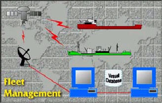
Since every installation is different, the system has been designed to be 'scalable' and may be easily configured to work with your existing communications infrastructure

<< back


Copyright Euronav 1991-2009
k